Skagway, the Juneau Road and the tricky question of socioeconomic integration
The Alaska Redistricting trial is nearing its close.
Good evening, Alaska!
In this edition: As the Alaska Redistricting trial is nearing its end, the Skagway case gets pretty interesting.
Redistricting trial day: 10
Spice level: 🌶️
The Road to Juneau
The last few days of the redistricting trial have started to blur together with just about every variation of question about the relative socioeconomic integration of just about every village, city and borough in Alaska posed to just about every witness that has been in front of the court. Making the case that socioeconomic integration is grounds to invalidate the maps is going to be a tough sell when the Alaska Constitution and the legal precedent give the Alaska Redistricting Board broad latitude to decide what is relatively socioeconomically integrated. For example, the court previously ruled that anything within a municipal boundary is automatically considered socioeconomically integrated. And besides, as the testimony of the past two weeks has demonstrated, socioeconomic integration is largely in the eye of the beholder… and just how creative the beholder is willing to get.
Is the village of Holy Cross more socioeconomically integrated with the road system town of Glenallen that’s nearly 450 miles away as the raven flies than Russian Mission about 70 miles down the river? The Alaska Redistricting Board says the former.
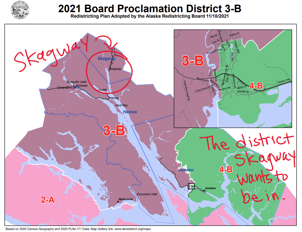
Anyways, that’s all to say that at least today’s challenges to the board’s decision to sever ties between Downtown Juneau and Skagway made for one of the more interesting challenges to the socioeconomic connections of the maps produced by the Alaska Redistricting Board. Here, Skagway argues the board ignored the city’s obvious socioeconomic connections to Downtown Juneau—as well as nearly unanimous public testimony in both Skagway and Juneau—when it paired them together with Mendenhall Valley in creating House District 3. We saw the argument develop more today with a big focus in on Skagway’s reliance on the tourism industry, it’s connection to professional services in Downtown Juneau and its opposition to the controversial road project that could connect Juneau to Skagway.
Here’s the board’s finalized map that’s in question:
Testimony from the Skagway officials was essentially along the lines of “Why fix something that’s not broken?” They argued that the existing map (below) that paired Skagway, Haines and Gustavus with Downtown Juneau was a far better representation of the region’s shared interests and should have been maintained. They argued that the near-unanimous satisfaction with the status quo left them shocked when the map was shaken up so significantly by board member Budd Simpson, who was appointed by Gov. Mike Dunleavy.
Keep reading with a 7-day free trial
Subscribe to The Alaska Memo by Matt Buxton to keep reading this post and get 7 days of free access to the full post archives.


